Recently Viewed ›
Recently Downloaded 
Close x
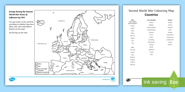
If you’re looking for a way to cement your 3rd to 5th grade learners’ knowledge on the factions that formed during the Second World War and how they interacted as affected by geography, you can’t go wrong with our World War 2 Europe Map Worksheet. Of course, this is a Map of WW2 Europe only, but it’s a great base to chronicle the events before going further into major players outside the continent, such as Japan and the USA.
The World War 2 Europe Map Worksheet, while covering a serious topic, comes in an engaging format: a coloring activity featuring the Map of WW2 Europe. Using this resource, students must categorize the countries listed into Allies, Axis, Axis Controlled, or Neutral, making historical events easier to visualize in grasp as seen on a map. Fret not about looking up the countries and groups yourself, though, as this comes with the answer key!
 ww2
ww2 map
ww2 timeline
war
world war 2 timeline
world war 2 activities
world war 2 map
ww2 allies and axis
europe map
ww1
anne frank
ww2 activities
ww2
ww2 map
ww2 timeline
war
world war 2 timeline
world war 2 activities
world war 2 map
ww2 allies and axis
europe map
ww1
anne frank
ww2 activities
Awesome
Hello bababi4769,
It's always lovely to hear that people like our resources. Thank you so much for taking the time to comment.
 4 years ago
To scaffold the children's knowledge of the war in Europe
Hello JuliaPDavis,
I'm glad you found this resource useful
You may also like this resource: https://www.twinkl.co.uk/resource/t-t-5633-world-war-two-interactive-timeline-and-map-powerpoint
 4 years ago
 love it you can even change the date well sort of i rate it 10/10 but i want other countries like
 japan and america and and china
It is possible to have this in Romanian? Thank you!
Hi ale.moarcas,
Thank you for your fantastic suggestion! Because we receive so many lovely requests each day, we are unfortunately unable to make all of the resources requested (although we do our best!) If we can make your resource we will be in touch to let you know, though we cannot guarantee when it will be completed. If there is anything else I can help with, please let me know! Have a great day :)
 7 years ago
Great start to WW2 topic
how to download
Hello helenw72877471,
Thank you so much for getting in touch! It's lovely to hear from you. You can download this resource by clicking on the green 'download' button above.
 4 years ago
Hi,thanks for crating this resource, this worked very well with my y6 students.Could you please add america to this map.I'd give that to my mastering students.Thanks.
Hi igamos,
Thanks for your lovely request - I'll ask our design team to take a look and see if we can make this change for you :)
6 years agoGreat resource. It would be useful to have a list of what side each country was on just to make it easier to teach.
Hi missp85,
Thanks for your lovely request - I'll ask our design team to take a look and see if we can make this change for you :)
 6 years ago
Start of WW2 topic thanks.
Hi middle123,
You're very welcome :)
 7 years ago
is there a world war one map similar?
Hi Hmcairns,
Thank you for commenting. I have put this request through, if we're able to make it then we'll be in touch to let you know! :)
7 years agoHi, was a WW1 version created of this resource? Thanks.
Hi there,
Thanks for your lovely request! I have contacted our design team about a First World War version of this resource so it should be on its way soon! :-)
 6 years ago
Hi GeordieCroz,
Thank you for your lovely request! I have put it through to our design team to check to see if this is in the process of being created or if someone could please create it. Someone will be in touch soon, to say if it has been made or if it is possible :)
 6 years ago
Hello again! Good news! Our design team have confirmed a world war one version is currently been created! Keep your eyes peeled on the site :)
6 years agoww2 topic introduction
Hi traci3, thank you for your comment! :)
 8 years ago
Turkey was a Neutral country and did not take part in WW2
Hello sedefc,
Thank you for your feedback. I'll get this resource checked right away!
 3 years ago
Hi there sedefc,
Thank you so much for letting us know about this issue! Our lovely resource creation team have amended the resource and the new version is now available to download.
 3 years ago
Could you please send this to me in another format other than the WinZip file as my computer won't let me access it. Thank you
Hi DEaton84,
Thanks for getting in touch and I’m sorry you’re having trouble opening this ZIP pack. If you’re having difficulties extracting the files, we have advice on our Help Centre about the software that you will need for this: https://www.twinkl.co.uk/help/fix-a-problem/i-cant-extract-the-files-from-a-zip-pack.
I’ll send the file over to you by email right away so you can have another try, but if you’re still having trouble, let me know and I can take another look :)
5 years agoNot wishing to be negative about the resource - some parts are correct, like the Baltic states, but this map also has major inaccuracies. Germany and Poland had very different borders in 1939. So did Hungary, Romania and Czechoslovakia. Macedonia and Slovenia were part of Yugoslavia back then. Armenia, Georgia and Azerbaijan were part of the Soviet Union. Can it be corrected?
Hi alwayshope,
Thank you for getting in touch with us. I apologise if this mistake has caused any problems. I'll let our resource creation team know about it right away and they will get it fixed as soon as they can!
 6 years ago
Hi there alwayshope,
Thank you for spotting this mistake! Our lovely teacher and design teams have solved the issue and the new version is now available to download. I hope you like it!
6 years agoThanks! You've done a really good job there! One final piece of pedantry... The nation of Macedonia was part of Yugoslavia in 1939. Most people won't notice, but we do have pupils from the Balkans who would. Cheers
Hi alwayshope,
Thanks for spotting this! I do hope it hasn't caused you any issues. We'll let our resource creation team know right away and get this fixed :)
6 years agoNice resource but proved a bit confusing as there are missing borders between the Soviet Union and Finland and Turkey and middle Eastern countries (I can understand not naming the middle eastern countries in a European map but the Turkey border would be useful). In addition, as we had been discussing surrender of Holland and Belgium it was a shame that they did not appear on the map and instead seem to have been subsumed into France or Germany. A few amendments would make a nice resource into a much more useful one.
Hi AllieKatz,
I was really sorry to hear about this mistake, and I apologise if it has caused you any trouble. It will be changed shortly!
 8 years ago
Hi there AllieKatz,
Thanks for spotting this mistake! We have now corrected it and emailed you the amended resource, I hope you find it useful. It will also be updated on the website soon.
8 years agoI am using it for ESL camp with my students
Hi dehoflis,
Thank you for sharing! :)
8 years agoA shame that the Channel Islands are not included on the map, especially seeing as they were the only part of Britain to be occupied during the second world war - a very important part of our history that is usually forgotten about!
Good evening RosieB84,
Thank you very much for commenting! It's great to hear from you :) I will see if one of our lovely designers can include the Channel Islands for you :) Have a lovely evening :)
7 years agoHi there RosieB84,
Our lovely teacher and design teams have completed this for you and emailed the new resource, I hope you find it useful! It will also be available for download on the website within 48 hours, and you can find it either as a main resource, or under 'Alternative versions' above.
7 years agoDisappointed, doesn't present the correct borders of Germany during WWII or pre WWII, I don't see Finland controlling the Petsamo, which it should if this map does take place before 1940, and if it doesn't take place before 1940, and it takes place after 1940, then the Soviet Union should have gained small portions of land on the Finnish border via the Winter War, which is not shown. The borders of Germany should include north-west Poland and Eastern Prussia, as well as Austria if this map takes place before 1939. This map presents the modern borders of the countries in WWII, with exceptions of the Soviet Union and Yugoslavia
Hi Timothy_Alejado,
Thank you so much for letting us know about this one. I'll ask our resource team to look into this as soon as possible! :)
7 years agoOther than that it's great, and by the way, make the countries north of Iran part of the Soviet Union, they weren't independent during the war, and were a target during Germany's attack on the Soviet Union, and I don't know if I'm right on this but on your map it appears to be water below Lithuania, my map is showing that area of water to be Germany's Eastern Prussia
Hey there,
Thank you. I've asked our resource team to look into this and to make any necessary amendments.
Have a lovely evening! :)
7 years agoHi there,
Thanks for getting in touch and letting us know about this issue.
As you point out, territory was constantly gained and lost throughout the conflict, so it is difficult to show the minutiae of border change in one map. This resource is instead intended to give a broad overview of the alliances that were in place during WWII.
If you wanted to personalise the activity to a particular year or period within WWII, we have added a blank map version (available in the 'Alternative versions box' that includes a blank map you can use to make your own answer sheet. I hope this helps!
7 years agoThe WW2 Map and List of Countries is incomplete. Please let me know when it is amended.
Hello FrancoisePR,
Thank you for your feedback. I'll get this resource checked right away!
4 years agoHello there,
Thank you for getting in touch. Our lovely teaching team have reviewed this resource and are confident that all the European countries are included. Could you give us a few more details about the problem you have had so we can troubleshoot this further?
I look forward to your response!
4 years agoHi, The key is missing from the editable version, could this be added please? Looking forward to using this with my yr 9s
Hi SanaBh,
Thanks for spotting this! We'll let our design team know right away!
6 years agoHi there SanaBh,
Thank you for spotting this mistake! Our lovely teacher and design teams have solved the issue and the new version is now available to download. I hope you like it!
6 years agoThank you so much! :)
Hi there,
You are very welcome! :-)
6 years agoHi,I used this resource last year and it was great. However, my children found it helpful if the Sea and Oceans were coloured in blue (I tried with just the black and white version and I had some very interesting maps of Europe!). I ended up spending ages colouring it in myself and then photocopying it. Would it be possible to get a version with those areas coloured in? I am coming up to WWII again and would love to use this!Thanks
Hi Leesia,
Thanks for commenting! I can see this being a useful addition - I'll ask our design team to make the amendment!
 7 years ago
Hi there Leesia,
Our lovely resource creation team have completed this and emailed the new resource to you, I hope you find it useful! It will also be available for download within 48 hours, and you can find it either as a new resource, or under 'Alternative versions' above.
7 years agoI would also very much like to use a map with seas and oceans coloured blue. My pupils last year created some very interesting map work without this extra support. I can't see this available under the 'Alternative versions' above, as stated previously. Please could this be added?
resource won't download!! Very disappointing!!
Hi kirsty98,
Thank you very much for commenting! It's great to hear from you :)
The reason you can't download the resource is because you are a free user. This resource is a paid resource and requires a subscription to download.
If you would like to subscribe you can do that here: https://www.twinkl.co.uk/premium
Have a lovely day :)
7 years agoCompleted map would help for marking!
If you’re looking for a way to cement your 3rd to 5th grade learners’ knowledge on the factions that formed during the Second World War and how they interacted as affected by geography, you can’t go wrong with our World War 2 Europe Map Worksheet. Of course, this is a Map of WW2 Europe only, but it’s a great base to chronicle the events before going further into major players outside the continent, such as Japan and the USA.
The World War 2 Europe Map Worksheet, while covering a serious topic, comes in an engaging format: a coloring activity featuring the Map of WW2 Europe. Using this resource, students must categorize the countries listed into Allies, Axis, Axis Controlled, or Neutral, making historical events easier to visualize in grasp as seen on a map. Fret not about looking up the countries and groups yourself, though, as this comes with the answer key!
For a creative exercise that helps your learners reflect on the role and heroism of American soldiers in the Second World War, we recommend our Design a D-Day Medal Activity. This resource contextualizes the idea of awarding medals after a war and prompts students to conceptualize designs of their own.
To aid your learners in putting events they learn about in social studies into perspective, look no further than our Key Events in World History Timeline for 3rd-5th Grade, which spans 18 points in history, from the Stone Age and ancient civilizations to the series of wars and the Apollo 11 Moon Landing.
And for a great way for your learners to relate to things that happened a long time ago, try The Lion, the Witch and the Wardrobe ClickDoc - A Complete Novel Study Unit. While most of the story happens in Narnia, the story begins with the Pevensie siblings having to be evacuated from London to stay safe from the fighting.
 Home
Home  Membership
  Customer Support
  Create
  Blog
Blog